hat if archaeologists had very limited time to find all that there was to be found, or else it risked being lost forever? Owing to thawing permafrost and rising sea levels that is precisely the nightmare now facing archaeologists in much of the Arctic.
A widely quoted IPCC (Intergovernmental Panel on Climate Change) scenario predicts a global temperature increase of around 2°C by the end of the century, with projected sea-level rises of about 0.5m. However, because global warming is much more severe at high latitudes, the same model predicts a 6.4°C temperature increase for the Canadian Arctic, with sea-level rises closer to 1m, a phenomenon known in climate-science circles as ‘Arctic amplification’. Where freezing temperatures once preserved organic materials and delicate structures in an endless deep freeze, rising temperatures are now exposing them – but if they are not quickly recovered and preserved, they will perish. Archaeologists are thus faced with a potential catastrophe but, ironically, also a once-in-a-lifetime opportunity for research.
Climate-change impact
For the Inuit who live along the northern coasts of Alaska, Canada, and Greenland, climate change is already destroying their cultural heritage and that of their forebears. Though tens of thousands of archaeological sites have been identified in the North American Arctic, only a small percentage of them have been excavated. The ongoing loss of such material will hamper our attempts to fully understand the region’s past – from refining the big questions concerning the first peopling of the area, to unravelling the cultural evolution of the Inuit.
Inuit are fishers and hunters who have traditionally favoured the coasts. Unfortunately, these are precisely the places most vulnerable to the effects of climate change, notably coastal erosion. The coasts facing the Beaufort Sea have receded at an average rate of loss of 5.6m per year since 1980, for example. This is in fact much faster than would be expected based on the rate of sea-level rise, so how does this happen? Northern coasts have traditionally been protected by sea-ice throughout the year, forming a barrier that extends 30 or 40 miles from the sea shore even in summer months. The sea-ice protects the coast by dampening the impact of large waves and storm surges. But in recent years the summer sea-ice extent has been dramatically reduced, leaving coasts exposed to the action of waves, and the frequency of storms has also increased – hence more erosion.
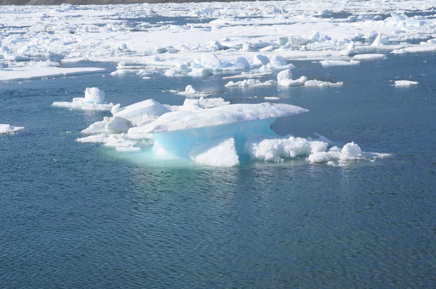
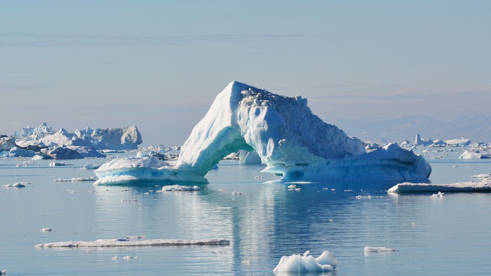
A floating ice shelf. Image courtesy of CyArk.
Other climate impacts are less obvious. Further inland, the tree-line has moved 60 miles north in the last 30 years due to warmer weather. Not a problem in itself, but a forested landscape makes it harder to find archaeological sites, as well as to excavate them, and tree roots can disturb stratigraphy.
Though climate change is more of a high-profile political issue for present- day coastal communities, many of which will need to be relocated in the next few years, it also threatens archaeological sites, including those that remain undiscovered. For archaeologists, the challenge has been locating these at-risk sites, and finding the resources to study and record them. Currently, it feels a bit like drinking from a firehose: in some cases, sites have been washed away before funding applications to excavate them have even been processed.
Deep-freeze history
Thanks to the extremely low temperatures, Arctic archaeology is unusual in the amount of well-preserved organic material that has been found. Familiar examples are the woolly mammoths recovered from the Russian Arctic, often with flesh and fur, sometimes so well preserved that they could still be eaten (as a team of gung-ho Russian researchers once demonstrated). In contrast, even though the mammoth’s habitat range extended into southern Europe and south of the American Great Lakes, only tusks and bone have survived in those warmer locations.
Perhaps one of the most-famous archaeological finds to be revealed as a result of climate change happened in northern British Colombia in 1999, when three hikers found a walking stick and a piece of fur emerging from the face of a retreating glacier in the Tatshenshini- Alsek Park, near the border with the Yukon. After consultation, and with the support of the Champagne-Aishihik First Nations on whose territory it was found, further investigation revealed the body of a young man aged about 18 years old, who had died in around 1700 AD, probably by falling into a crevasse in the glacier.
Subsequently named Kwäday Dän Ts’ ìnchi, which in the local language means ‘Long Ago Person Found’, he has yielded a wealth of information. From his stomach contents and pollen found in his colon, we know that he had travelled up from the coast about 60 miles away, and in the summer, and was equipped for hunting with a knife, an atlatl, and a dart, and was dressed in a robe made from 95 gopher skins and a woven hat. Comparison of his DNA with living members of the Champagne-Aishihik First Nations found that he was related to 17 of them through his direct maternal line. Fifteen of those people identify with the Wolf clan, suggesting that Long Ago Person Found might also have been in the Wolf clan. In 2001 his body was cremated at the request of his descendants, and his ashes returned to the glacier.
Meanwhile, in the Yukon, retreating snow and ice cover has even given rise to a whole new branch of archaeology – ‘ice- patch’ archaeology – whose main subject of study is caribou faeces. What is so interesting about caribou droppings? In order to escape the heat and the insects during the summer months, caribou often congregate on the ice patches that form in the shadow areas of mountains, so their dung ends up sandwiched between layers of winter snow, rather like one of those very elaborate layered cakes or perhaps a tiramisu. The dung contains pollen spores, plant fragments, seeds, insects, and parasites, which provides a rich source of information on environment, vegetation, climate, and caribou populations.
The Yukon Ice Patch Project is a joint research project between the Yukon Government and six First Nations communities, and was established in order systematically to gather environmental data going back 9,000 years, a mission given new urgency as many of these perennial ice patches are now melting. Many artefacts have also been found from the caribou’s human predators, including projectile points, darts, atlatls, knives, and even moccasins. These artefacts help to tell the story of the evolution of hunting techniques, revealing, for example, how throwing darts were used with little modification for almost 6,000 years, until they were abruptly replaced by bows and arrows around 800 AD. Ice- patch studies have since been conducted in Norway, where similar data and artefacts have been found, showing that the Vikings and their predecessors were also hunting caribou on ice patches as long ago as 3000 BC.
These are the stories with happy endings, where archaeologists got there in time. Given the harsh conditions (blizzards in the winter, clouds of insects in the summer), the remoteness, the short field-season, and the logistical challenges in reaching these sites, it is clear that traditional archaeological methods will not be sufficient for studying them all. Is there a way we can record them more quickly?
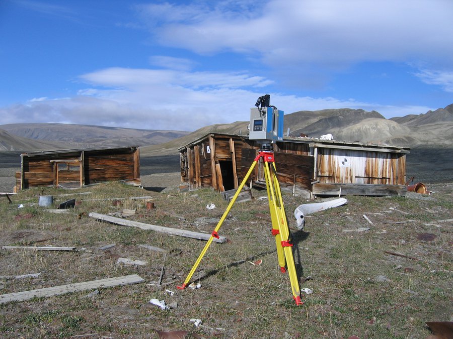
A terrestrial scanner used to record archeological sites in astonishing detail. Image courtesy of CyArk.
High-tech rescue
Cutting-edge technology is providing solutions. Three-dimensional terrestrial LiDAR laser-scanning shows great promise, both in the Arctic and in other environments where structures are threatened with destruction. The technique can record sites in astonishing detail, in a way that allows scientists to make virtual reconstructions of the object – either on a computer screen or in a 3D holographic room that is rather reminiscent of the ‘holodeck’ in Star Trek.
Multiple scans from different vantage points are required to ensure complete coverage without shadowed areas; large scenes such as a landscape may require scans from perhaps a hundred different positions. Colour is overlaid on the laser- scanned surface by taking high-resolution digital photographs from the scanning positions. Recording an archaeological site in this way is considerably faster and more accurate than using traditional surveying methods – an area the size of a couple of football pitches can be surveyed in a week, for example.
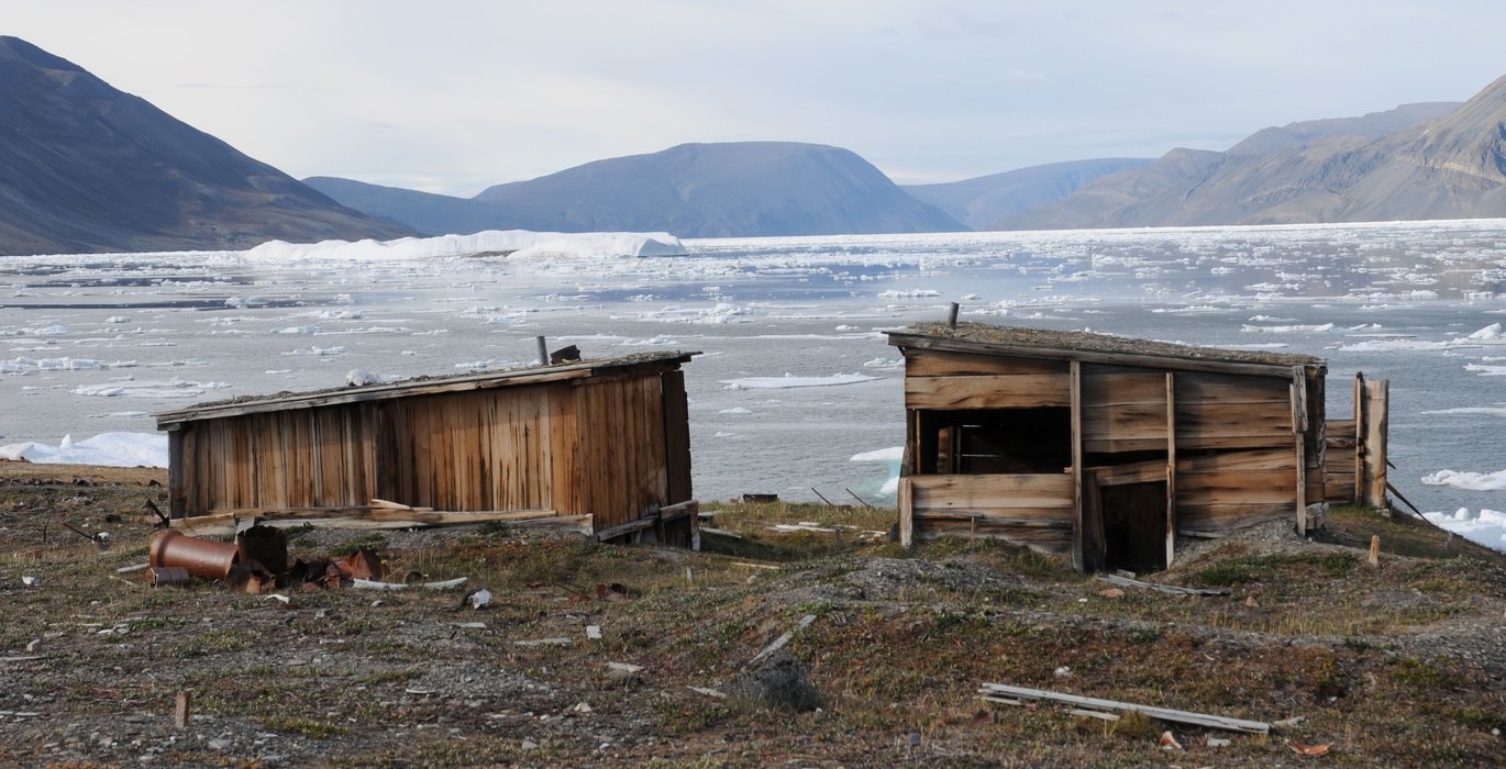
The first time terrestrial laser-scanning was used in the Canadian High Arctic to record a heritage site was in 2010, when Dr Peter Dawson of the University of Calgary, and a Research Associate at the Arctic Institute of North America, was asked by Parks Canada to investigate the possibility of using the technology to record Fort Conger, a key heritage site for early Western exploration of the Arctic, located in a remote north- eastern corner of Ellesmere Island, about 60 miles south of Alert. It is almost as far north as you can get and still be in Canadian territory.
Originally built in 1881, during the Lady Franklin Bay Expedition, as a meteorological and astronomical observation station for the First International Polar Year, 25 men lived at Fort Conger for two years. It was later used by Robert Peary between 1899 and 1909 as a staging post for his attempts on the North Pole, as well as by other expeditions until as late as 1935. In many ways, Fort Conger represents the coming together of Western exploration with native knowledge of the Arctic. Following earlier Arctic exploration failures, Peary employed Inuit (Inughuit) families from northern Greenland as his primary workforce at Fort Conger, learning much from them about their traditional methods of travelling, hunting, clothing themselves, and building shelters.
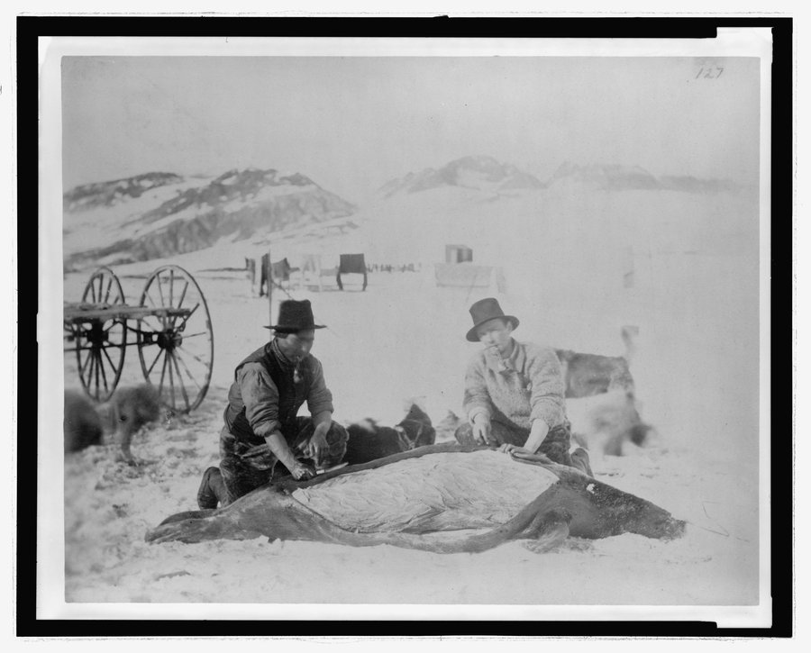
Two members of the Lady Franklin Bay Expedition at Fort Conger, Discovery Harbour, Ellesmere Island, Quttinirpaaq National Park, Nunavut, Canada, skinning a seal. On the left is West Greenlander Jens Edward whose hunting and dog sledging skills greatly aided the expedition. He drowned while qayaq hunting on 29 April 1884. On the right is the expedition’s surgeon and naturalist, First Lieutenant Dr. Octave Pavy, who died shortly before the rescue mission reached the survivors in June 1884. Note the wheeled cart in the background. [Greely Expedition Photograph]
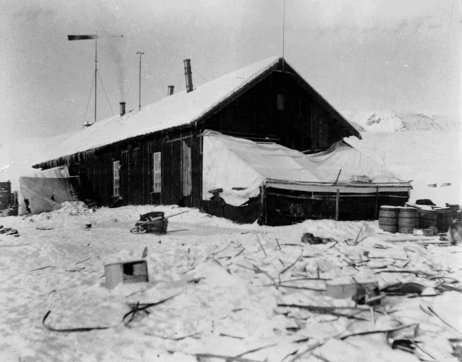
Greely’s expedition house at Fort Conger, as it appeared to Robert Peary in 1899-1900 when he arrived at the site and began to use it as a base camp for his own attempts to reach the North Pole. Peary initially set up quarters in the Greely structure as his party occupied the central galley / kitchen area while insulating the walls dividing these rooms from the other interior spaces. He eventually concluded that the Greely house was unsuitable and when his resupply vessel was unable to reach Fort Conger by August 1900, he set in motion an emergency plan involving the dismantling of the Greely structure and re-use of the lumber to build the three smaller Inuit-influenced shelters which still stand today. Image Courtesy of the Robert E. Peary Family Collection
Today Fort Conger consists of three dilapidated wooden huts a mere 30 feet from the shore of Discovery Harbour, and a precarious 10 feet above the high-water mark. Adding to the difficulty of doing a conventional archaeological investigation of the site is the presence of high levels of arsenic trioxide, a toxic legacy of the expedition originally used to preserve natural history specimens. Removing the contaminated soil would pose a significant threat to heritage resources present at the site.
Together with his colleagues Dr Richard Levy, from the Faculty of Environmental Design, and Chris Tucker, President of SarPoint Engineering in Calgary, Dawson partnered with CyArk, an international non-profit organisation dedicated to using new technologies such as laser-scanning to create a free online 3D library of world- heritage sites in danger of being lost, whether through climate change, human aggression, or simply the ravages of time.
CyArk has used the raw data from Dawson’s survey to create a web portal with a 3D image that can be viewed interactively. The same data can also be viewed in an immersive 3D viewing room, as well as for generating conventional outputs such as 2D images and floor plans. All this allows the entire building to be ‘reconstructed’ and studied in detail elsewhere, as well as being accessible to a wider community than would normally be the case – and all without the risk of arsenic poisoning!

3D Point Cloud of Henson’s Hut. Image courtesy of CyArk

3D Point Cloud of Dedrick’s Hut (interior). Image courtesy of CyArk
Modelling the past
The technique has also been used by Dawson and Levy to record and study Inuit architecture: in one case, they have been able to use it in conjunction with computer-modelling to reconstruct buildings that have long since disappeared.
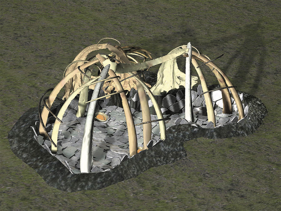
Contrary to popular belief, the local inhabitants, the Inuit, have not always lived in igloos. In the late 12th and early 13th century, their forebears in the North American Arctic and Greenland, expanded eastward from the Bering Strait region. Because there was little driftwood available, they built winter houses known as igluryuit from whalebones: a framework of bone was placed over a house pit, then covered by thick layers of hide and turf. The collapsed remains of such houses have been found, but none exist intact. Scanning of whale skeletons and computer-modelling have been successfully used to reconstruct ‘virtual-reality models’ of the houses, which could then be used to work out how they would have been constructed, and what they looked like inside.
Moving to the Mackenzie delta area, plenty of driftwood comes down the Mackenzie River, which is Canada’s largest river system and second only to the Mississippi in North America. The Inuvialuit people who lived here in centuries past built sod houses from a combination of driftwood and whalebone. For some 500 years until its people were largely wiped out at the end of the 19th century by diseases brought by white missionaries and traders, the largest settlement in the area was Kuukpak, a village of several hundred people living in several dozen large multi-family sod houses.
Computer reconstruction of a Thule whalebone house. Image courtesy of Dr. Richard Levy and Dr. Peter Dawson, University of Calgary
Kuukpak was an excellent location. Located on an island in the delta alongside where the Mackenzie River empties into the Beaufort Sea, it is an area where beluga whales gather in the summer, the river itself provides year- round fish, and inland there is access to great herds of caribou. The Mackenzie River’s constant supply of driftwood could be used not just for building but also for fuel. However, Kuukpak has the fastest-rising sea level along the entire Arctic Canadian coast. With the coastline receding at 5-10m per year, much of the settlement has already been washed away. Since the abandonment of Kuukpak over a hundred years ago, the sod houses have collapsed, and until two years ago not one complete example of a sod house had been excavated, meaning that understanding of how they were constructed or used was limited.
It is estimated that within ten years Kuukpak will have completely eroded, so in order to preserve this unique architecture and understand better how the houses were built and used, Adam Jahraus, a graduate student in Geomatics Engineering at the University of Calgary, who is co-supervised by Dawson and Dr Derek Lichti, used a laser-scanner to record 3D images of the component wooden beams excavated from a site at Kuukpak. These data will be used to modify an earlier virtual-reality computer model constructed by Dawson and Levy to study how they were constructed, and to view the inside of the complete structure to elucidate how they were occupied, including airflows and lighting. It turns out, for example, that the entrance tunnel was built lower than the living area to form a kind of trap to keep the warm air in, since cooler air sinks. Many small artefacts have been recovered from excavations of igluryuit in recent years, so these have also been scanned and placed within the virtual-reality model, including tools, lamps, combs, fishing and hunting equipment, knives, and what are thought to be gaming pieces.
Regardless of whether you are an optimist or pessimist when it comes to our ability to reduce CO2 emissions, on current warming projections it is likely that a great many archaeological sites in the Arctic will be lost before the end of the century. Hopefully techniques such as laser-scanning and computer-modelling will allow these at-risk sites to be recorded and studied, so going some way to ‘preserving’ them for future generations – before they are gone forever.
Dr. David Millar is a science writer focusing on archaeology and past climate change, and a Research Associate at the Arctic Institute of North America, University of Calgary, Canada.
This article was originally published in Current World Archaeology.